

If you were to guess one of the most deadly seismic areas in North America, one would probably quickly guess the San Andreas seismic area, but in actuality the most deadly, and the fault-line that can effect a much larger radius would be the New Madrid seismic zone. Most people have never even heard of the New Madrid fault line, let alone guess that the most powerful earthquake on the continental United States happened there exactly 200 years ago in 1811. It registered an 8.0 magnitude on the Richter scale while devastating large swaths of towns, and villages around a 250km area. Records were kept on it's severe devastation, and the shock was felt as far away as Philadelphia, and even causing church bells to ring in Toronto (then York) over 1000km away!
What I will present in this article is information, a chronology, and evidence regarding what I think is the deliberate tampering of fragile seismic zones, and the engineering of one of the largest seismic events we have seen in our time. I will cover everything from scalar weaponry, weather modification, and ionospheric heating, because all of these events and apparatuses are connected to this event, and many other events around the world in recent time.
PREFACE
FEMA's National Level Exercise 2011
To give a background of Federal attention given to the New Madrid Seismic zone, you can look into a report published back in November of 1988 by the Army Corps of Engineers. In regards to the exact same scenario of flooding and how it would be "economically beneficial" to blow the levees outside of Cairo, Illinois to relieve pressure from the Mississippi and to flood the area directly to the south of the levees, onto the New Madrid Seismic Zone. In this report, they also briefly mention how there is a possibility that this could trigger one of the most volatile seismic zones in the United States. And in 2008 the FEMA published a report in which it stated that there is a significant threat to the US in the New Madrid Seismic Zone (NMSZ). FEMA specifically targeted a 7.7 magnitude earthquake scenario in which it would displace almost a quarter-million households, cause $300 billion in damages, and killing nearly 100,000 people within, and around the NMSZ.
Every year since 2007 (Formerly known as TOPOFF), there has been a massive drill involving thousands of federal departments such as FEMA, the military, local law enforcements, and public service crews integrated into a massive emergency scenario. In January of 2011, FEMA announced that this years scenario would be the first 'natural' hazard scenario in celebration of the 200th anniversary of the New Madrid earthquakes of 1811 to 1812. As a result, on May 16th through the 21st of 2011 the 'NLE 2011' will take place, involving thousands of military personnel, thousands of law enforcement, and public service personnel.
To highlight the official release, it contains information on the FEMA Regions which will partake in this event:
NLE 2011 activities will take place at command posts, emergency operation centers and other locations to include federal facilities in the Washington D.C. area and federal, regional, state, tribal, local and private sector facilities in the eight member states of the Central United States Earthquake Consortium (CUSEC). The eight member states of CUSEC encompass four different FEMA regions: Alabama, Kentucky, Mississippi, and Tennessee (FEMA Region IV); Illinois and Indiana (FEMA Region V); Arkansas (FEMA Region VI); and Missouri (FEMA Region VII).

Through a comprehensive evaluation process, the exercise will assess response and recovery capabilities both nationally and regionally. The exercise is designed to validate the following capabilities:
- Communications
- Critical resource logistics and distribution
- Mass care (sheltering, feeding and related services)
- Medical surge
- Citizen evacuation and shelter-in-place
- Emergency public information and warning
- Emergency operations center (EOC) management
- Long term recovery
To remember a history of government responses to recent disasters to support the people is not a very pretty site when one remembers the aftermath of Hurricane Katrina. Where random people were shot and murdered by authorities for simply trying to leave a flooded mess. Or where the first thing the government does to respond to a crisis, is to send armed troops door to door to confiscate guns from law abiding citizens on their own property. That is not my idea of support. Or perhaps the recent BP Oil disaster? The largest ecological disaster of our time was literally censored out of existence. Many journalists within the entire radius of the spill area were arrested by government officials under orders from BP management! Who does the US government represent? You? What about Haiti? Or has that been wiped from your memory banks already. And the story continues.
Even more synchronizing and sinister is the coincidental occurrence of live scenarios under the guise of drills. For example, during the week up to and into the early morning of September 11, 2001, the Pentagon (under direction from Dick Cheney) was undergoing a significant drill in which multiple commercial jets were hijacked and targeted at specific targets like the White House, the Pentagon, the World Trade Centre among others. This drill involved multiple federal jurisdictions, including the Air Force. In a flight recording of an Air Force pilot, you can clearly hear the pilot's confusion when he is asked if this is "real-world" or "exercise" considering the fact that he was most likely doing similar drills before this took place.
On July 5, 2007 the London bombings took place in which 56 people died in mulitple explosions throughout the London transportation infrastructure by 'suicide bombers'. To give us a brief inside look at what really went on, we can look and see what Peter Power had to say about this 'exercise'. Mr. Power who is an advisor for many crisis management companies was overseeing a drill on that morning. He states that on the morning of July 7, he was overseeing an operation in which the exact same targets that were 'terror' attacks, were in fact the same targets in the drill. And how he was partaking in a simulation. Very ominous.
So please keep these historic scenarios on what I am trying to elaborate on through this article.
PART ONE
Ground Based Weather Modification
 |
| Tornado roars through Alabama in late April. |
What is particularly peculiar about these systems is that these systems are not entirely natural. In saying that, it is surprising to watch the infra-red weather radar while those systems passed through the United States. It may be a dead give away. Little is known about weather modification, including that which the public has been privy to. One of those technologies is Scalar waves. Scalar waves are an offshoot of some of Nikola Tesla's inventions using the Ultra Low Frequency (ULF) to Very High Frequency (VHF) bands. Essentially using frequency to change the state of the matter around it by heating a large or targeted area, or cooling a large or targeted area. Through the heating of the troposphere to create moisture and seed clouds and eventually storms if continually seeded, or cooling the troposphere to dissipate clouds, force clouds to rain, or kill storms right away. Although Scalar waves can be used in countless other capacities, we will only focus it on weather modification.
Now that you understand what Scalar waves are, let us take a look at how simple it is to apply these technologies to already existing radar apparatuses. Here, physicist Lt. Col Tom Beardon explains how easy it is to implement scalar field generators onto existing Doppler, and NEXRAD (Next-Generation Radar) Radar systems. These can also be operated from military radar stations throughout the US. The question is why would they? Unless of course there was some sort of agenda. These radar 'anomalies' were picked up by people as early as the late 1990's, so it's safe to say these scalar devices have been around a while. (Here is audio from a radio broadcast in the early 1980's of Tom Beardon talking about scalar weather modification.)
 |
| Ground based NEXRAD and Scalar Generating device. |
PART TWO
Flooding the Fault
Sitting on the aquatic crossroads of the Mississippi and Ohio rivers lies Cairo, Illinois. With a bustling population of 2,831 souls it has been chosen as the lucky winner to avert a flooding disaster by the US Army Corps of Engineers. Along the Southern half of the Mississippi are hundreds of miles of flood dams and levees to protect local communites and farmland along the Mississippi from flooding. What is unique and troubling about helping this town by blowing the dam along the Mississippi is where the flood water will end up being diverted to. Millions of pounds of water will be sitting on a very unstable seismic area. The pressure put on the NMSZ, combined with the massive amounts of flood water that will spill into the fault lines 4-15km below the surface could lead to a disasterous outcome that makes the current Mississippi floods seem like a cake-walk.
 |
| Area to be flooded by blowing levees. |
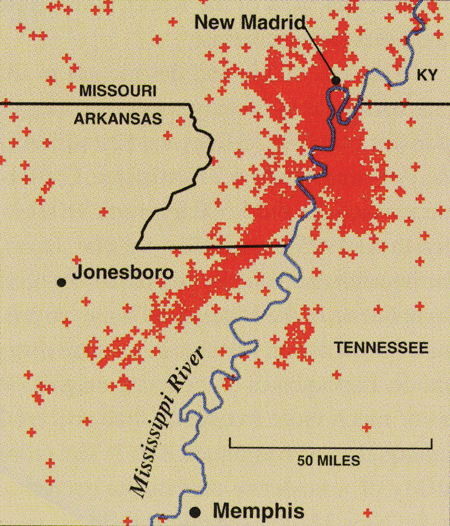 |
| Recorded Earthquakes in the NMSZ in the last 250 years |
Flooding fault lines, or known volatile seismic regions causes significant pressure to build up on the top of these plates, and drastically increases the chances of tectonic movement. Also, physically flooding the fault line directly, under the surface of the Earth significantly increases fault viscosity allowing the plates to move, or slip quite easily. These are known geological principles, and is exactly what is going on in the NMSZ. You could wonder how that flood water being diverted could get down into the Earth enough to actually physically flood the fault, and it can, and probably will due to the constant natural gas 'fracking'. Throughout the last decade in the US midwest has been the largest campaign of natural gas drilling and exploring ever. This drilling is called 'fracking'. 'Fracking' essentially creates massive holes in the shallow parts of the Earth's crust while exploring and forcing natural gas to the surface. It works by drilling massive holes deep into the crust, and then drilling holes horizontally for miles. After the holes are created, massive pressure is pushed down into these holes to expel the natural gas reserves up to the surface. This principle alone can cause severe repercussions for the crust of the Earth, and it's long term effect is unknown and dangerous for a stable crust. So if you combine fracking in the area of the NMSZ, it is easy to see how vast amounts of water can make it's way deep down into the fault zone miles below the surface and create instability for the entire area.
A separate note to include is the BP oil disaster from April 2010. It is important to include this because of where and how this incident happened and the repercussions it can have on the southern end of the New Madrid fault line which stretches into the north part of the Gulf of Mexico, directly connecting the deep volcanically active region of the Northern part of the Gulf of Mexico. The public is not entirely sure how the Deepwater Horizon wellhead was blown, but it is known that geological activity may have contributed to the explosion, if not, then a deliberate detonation to open up the bottom of the sea floor at that area of the Gulf. When the wellhead blew out, it seemed to have punctured deep into the Earth's crust, where it may have hit a very hot tar reserve. This would mean that it was very close, geologically speaking from some sort of seismic hot-spot in that area of the Gulf. Geologists have confirmed, and known about the seismic zones in the Gulf for quite some time, but when that area is punctured it creates an un-natural way for sea water from the Gulf to make its way down and spill into those seismic crevasses, and make a bad situation into a continentally catastrophic situation when combined with the flooding of the North end of the New Madrid fault line.
CONCLUSION
In reviewing the information presented here, it is safe to say that something is not right about this whole situation. Something just doesn't feel right with me, and my intuition, which is why I had to get this article out. Why are people not asking these questions pertaining to the severity of the situation that could be unleashed int he US mid west. And if the fault line does slip, how much devastation it may cause. The Army knows what their doing, the United States Geological Survey (USGS) should know the repercussions of flooding a known seismic hot-spot. So why is it that all we hear in the mainstream media is how wonderful the Army is for saving this little town by blowing a dam, and not even a whimper about what is directly underneath the area the Army is flooding? My end conclusion is that for some reason, 'they', whoever 'they' are, are carefully orchestrating this geological event for their own agenda, similar to countless other 'natural' and other events that have occurred in recent times, but their is nothing coincidental about it. Their had been talks on message boards, forums, blogs, regarding the New Madrid Seismic Zone in recent years, but now I am convinced that something big is about to happen in the NMSZ. And very, very soon. This event can cause severe disruptions to infrastructure near and around a significant radius around the NMSZ. Many bridges, dams, and levees are within that area which can be compromised. That area of the United States is also a major hub for oil and natural gas pipelines and many power companies would be significantly impacted, and would essentially slice the Achilles heel of the United States energy infrastructure.
Stay safe, keep your head up, be prepared, and don't trust FEMA, because you may be running into the maw of the beast. I will leave you a prophetic map by Edgar Cayce, and take a glimpse into what could be the beginning of the end for the midwest of the United States after now taking this map into serious consideration.

No comments:
Post a Comment